
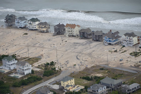
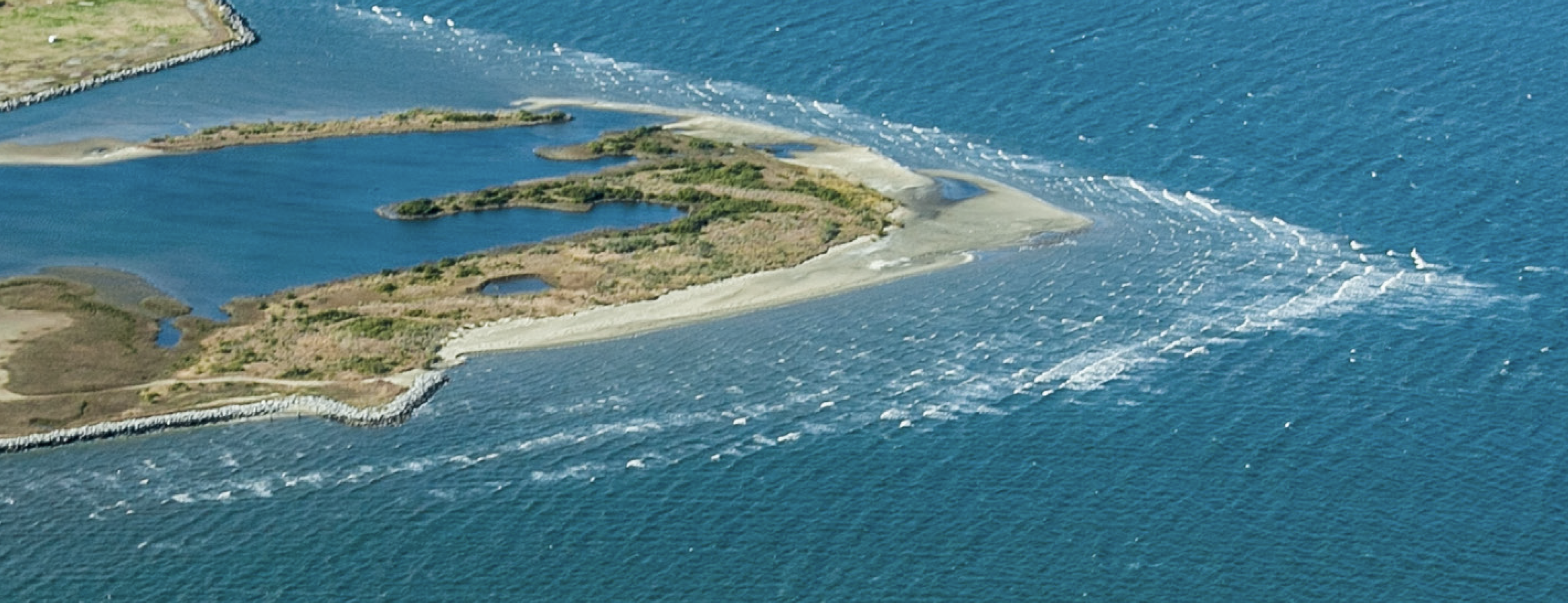
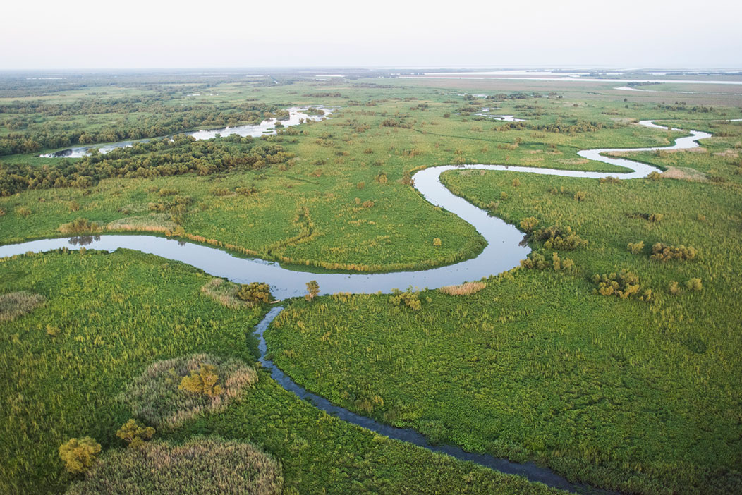
Open Space
Collaborating through the Community Rating System
Open Space
The Nature Conservancy is partnering with NOAA’s Office for Coastal Management (OCM) to coordinate efforts to meet the goals and objectives of coastal zone management in the U.S. and highlight those actions that also receive credits from FEMA’s Community Rating System (CRS).
WHAT IS CRS?
The Community Rating System (CRS) promotes comprehensive floodplain management and encourages communities to go beyond the minimum standards of the National Flood Insurance Program (NFIP). CRS is a voluntary program administered by the Federal Emergency Management Agency (FEMA) that rewards communities by providing policyholders discounts on their flood insurance premiums for activities that reduce flood risk. Activities include, but are not limited to, outreach activities about flood risk, floodplain mapping, and conserving open space.

WHY CRS?
Planning for growth and adaptation in the face of rising seas and the likelihood of more intense storms is vital to the economic security and wellbeing of communities across the nation. Participation in CRS incentivizes communities to take action to reduce their flood risk and improve resilience while making flood insurance more affordable.

CRS STRATEGY
Identifying flood risk reduction opportunities and applying for CRS credits can be overwhelming for many communities who don’t have the capacity to take full advantage of the program. To empower communities to fully participate in CRS, The Nature Conservancy is leading a strategy within the NOAA Digital Coast Partnership to enable planners to prioritize nature-based solutions to reduce flood risk, lower insurance rates, and improve community resilience.
Decision Support Tools
Digital Coast partner organizations including The Nature Conservancy (TNC), NOAA’s Office for Coastal Management (OCM), Association of State of Floodplain Managers (ASFPM), and Coastal States Organization (CSO) as well as Esri, are investing in the development of tools and guides to support communities in applying for CRS credits.
NOAA: How-To Map Open Space Preservation for Community Rating System Credits: This guide describes a stepwise workflow to help planners and GIS specialists identify eligible OSP parcels and calculate potential CRS credits.
NOAA’s Coastal Flood Exposure Mapper is another tool that can be used by communities to better understand flooding in their community.
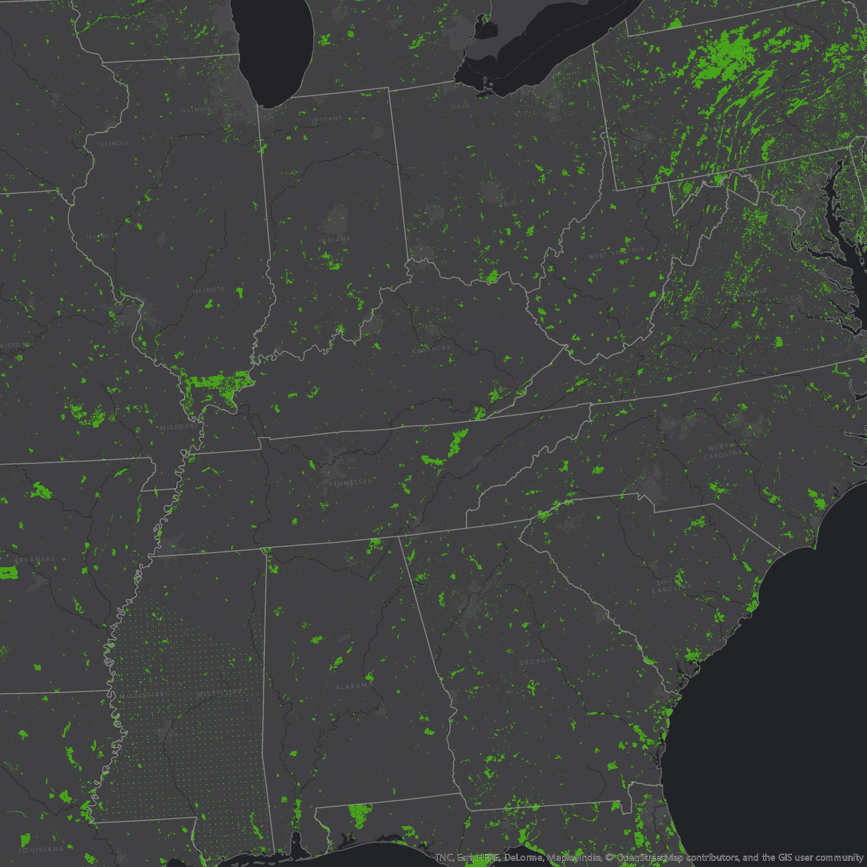
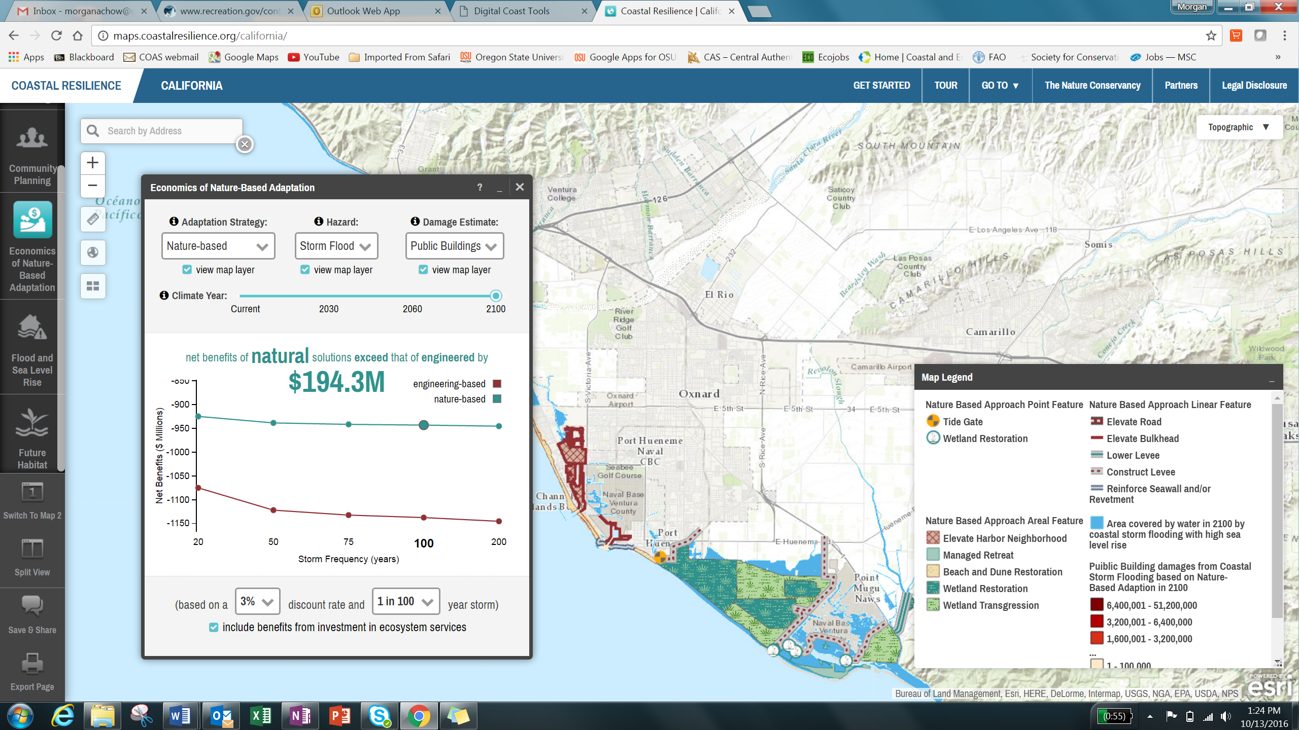
TNC: The Community Rating System Explorer app provides a mechanism to visualize and interact with outputs that come from the NOAA workflow and allows planners to more effectively engage decision makers, influence land management decisions, and explore unprotected parcels that may be most beneficial to protect for the future. OSP is one of many activities within CRS, and aligns with TNC’s mission to illustrate the value of nature-based solutions to reduce flood risk while also providing the largest amount of CRS points to communities.

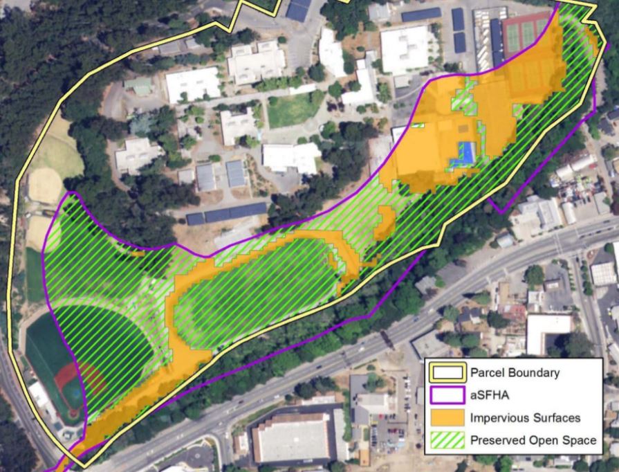
Elements Summary and Parcels that qualify for Open Space Preservation Credits in CRS Explorer.

Across eight communities in North Carolina, this tool identified an average of 546 eligible OSP credits, enough to promote each community at least one CRS Class, which would result in a larger flood insurance discount.
The CRS Explorer is expanding to the Gulf of Mexico where TNC and partners prioritized communities that have: a high probability of future flood damages and unprotected high conservation value open space as those that could benefit most from preservation as part of the CRS program. To ensure the app is replicable, updatable, and scalable to other communities across the U.S., a custom model is used to standardize the analyses needed to support the app while enabling communities to maintain their own data over time.
TNC and NOAA are also teaming up with ESRI to develop a national Open Space Preservation (OSP) Map that will be hosted as a downloadable image service on ESRI’s living atlas. This map will help to standardize screening-level impact adjusted OSP data for the nation with the goal of empowering communities that lack high resolution data to more effectively participate in CRS.
ASFPM and CSO: CRS Green Guide: features best practices and success stories derived from interviews with CRS communities earning top scores for CRS elements that preserve or enhance the natural and beneficial functions of floodplains (Funded by NFWF Hurricane Sandy Coastal Resiliency Competitive Grant Program).
Training and Outreach
- Instructor-led trainings and collaborative workshops that provide step-by-step best practices, live tool demonstrations, scenario based workflows, and assistance for implementation to maximize community participation in the CRS program and to help guide the CRS planning process.
- Success stories to engage local decision makers on the benefits of the CRS program and highlight lessons learned from top-scoring CRS communities.
- Online training resources for planners and GIS practitioners including decision support tool tutorials, E-Learning simulations, and comprehensive guidance documents.
Additional Resources
Related Stories and News
Nature-Based Solutions and the FEMA Community Rating System
The Georgia Chapter of TNC help to identify the states top climate research questions through a state-wide collaborative effort called the Georgia Climate Research Roadmap.
Access Open Space to Lower Flood Insurance Cost
Esri and TNC share the story of planners in a South Carolina community that are taking steps to help homeowners save an estimated $128 each on their flood insurance, as part of the Community Rating System, in a newly developed Esri Learn Lesson.
A Suite of Community Rating System Resources
TNC is excited to announce the launch of a suite of new products developed with Esri to help communities reduce their flood risk, make flood insurance more affordable, and increase their resilience through FEMA’s Community Rating System (CRS).
What does fire have to do with floods?
The Bay Area Open Space Council makes the link between fire, floods, open space preservation, and flood insurance premiums., and highlights NOAA’s GIS Workflow and Mapping Guide for the Community Rating System.
We got tools, are you using them?
Digital Coast fellows share some lessons learned from tool assessments they’ve conducted, both of which can inform a deeper look at specific outcomes and audiences the Partnership tools are designed to reach.
Happy Birthday!
NOAA’s Digital Coast website is turning 10 this year! TNC is a founding partner in what started as an innovative experiment designed to bring focused data, tools, and training to the people charged with addressing development and environmental challenges in coastal communities.
CRS back in action at Coastal GeoTools 2017!
Digital Coast partners teamed up with Climate Central to share their progress on the development of tools and resources to help communities increase their Community Rating System (CRS) credits at Coastal GeoTools 2017.